• Home
  • About
    • About Source Protection
    • About Our Region
    • Best Practices
    • Circumstances
    • Links
    • News
    • Septic Systems
    • Stewardship
    • Threat Activities
  • Contact
  • The Plans
  • Consultation
  • The Committee
  • Risk Management
  • Documents
  • Maps
  • Videos
Ausable Bayfield Maitland Valley Source Protection RegionAusable Bayfield Maitland Valley Source Protection Region

Ausable Bayfield Maitland Valley
Source Protection Region

  • Home
  • About
    • About Source Protection
    • About Our Region
    • Best Practices
    • Circumstances
    • Links
    • News
    • Septic Systems
    • Stewardship
    • Threat Activities
  • Contact
  • The Plans
  • Consultation
  • The Committee
  • Risk Management
  • Documents
  • Maps
  • Videos

Intake Protection Zones

Featured Image
  • Map of Intake Protection Zone (IPZ) 1 and IPZ 2 for the intake near Grand Bend beach – PDF file
  • Fact Sheet on Drinking Water Source Protection around Lake Huron Primary Water Supply North of Port Blake – PDF file
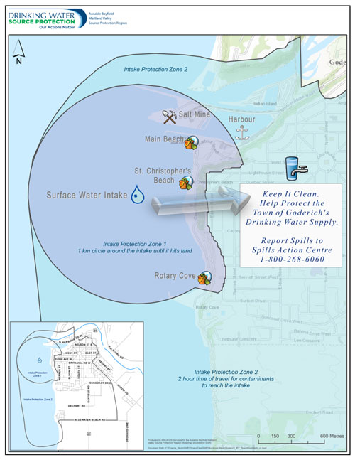
  • Fact Sheet on Drinking Water Source Protection near Intake Protection Zone (IPZ) 1 and IPZ 2 around Port of the Town of Goderich – PDF file

Ausable Bayfield Conservation Authority

Maitland Valley Conservation Authority

Ontario Ministry of the Environment, Conservation and Parks

© 2025 · Ausable Bayfield Maitland Valley Source Protection Region
The content provided here is intended for local educational and information purposes only. Every effort has been made to ensure the correctness of information as at the date of posting. Information is subject to change. For legislation and regulations visit https://www.ontario.ca/page/source-protection. This project has received funding support from the Province of Ontario. Such support does not indicate endorsement of the contents of this material.
  • Home
  • Sitemap
  • Contact
Prev Next